
Countries 3D Maps | Raised Relief Map by TestPlay
Explore Countries 3D Maps
Raised Relief Countries 3D Maps offer a panoramic way to explore entire nations through terrain and geography. This bird’s-eye view reveals mountains, plains, coastlines, rivers, and elevation changes with clear depth, capturing the geographic character of each country in a refined 3D composition.
-
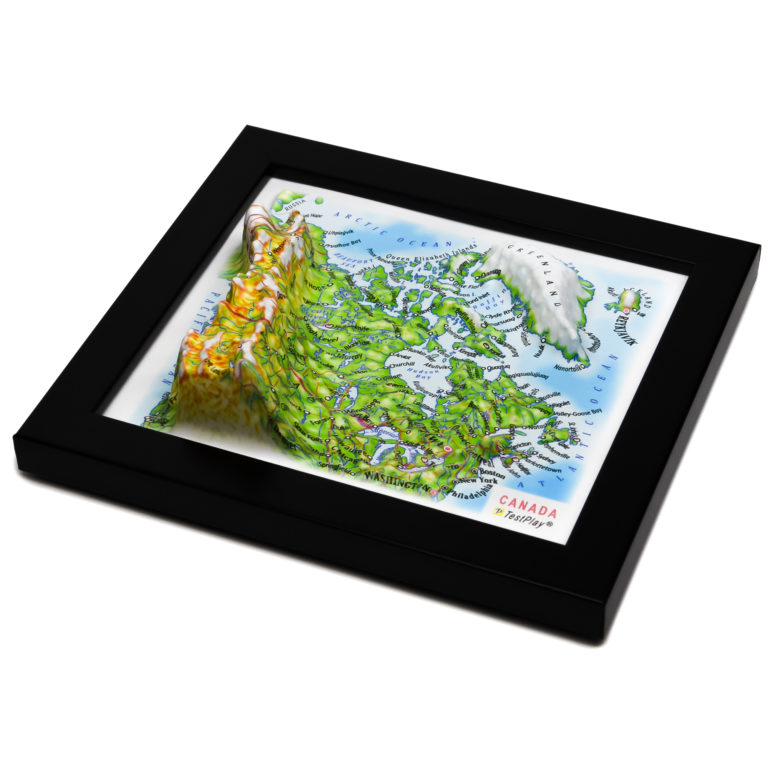
Canada 3D Map
Product Specifications:
✅ SIZE:
4.5 inches x 5.25 inches
(116 x 132 mm)
✅ 3D RELIEF HEIGHT:
Up to 1.5 inches (40 mm)
✅ MAP SCALE:
1 inch = 560.3 Miles
(1:35,500,000) -
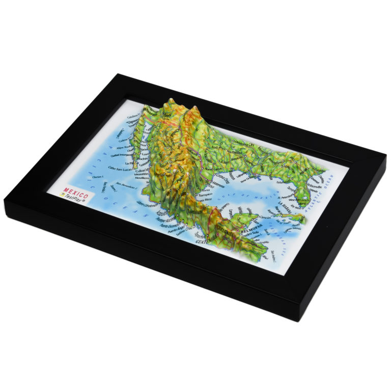
Mexico 3D Map
Product Specifications:
✅ SIZE:
4 inches x 6 inches
(100 x 150 mm)
✅ 3D RELIEF HEIGHT:
Up to 1.5 inches (40 mm)
✅ MAP SCALE:
1 inch = 493.25 Miles
(1:31,250,000) -
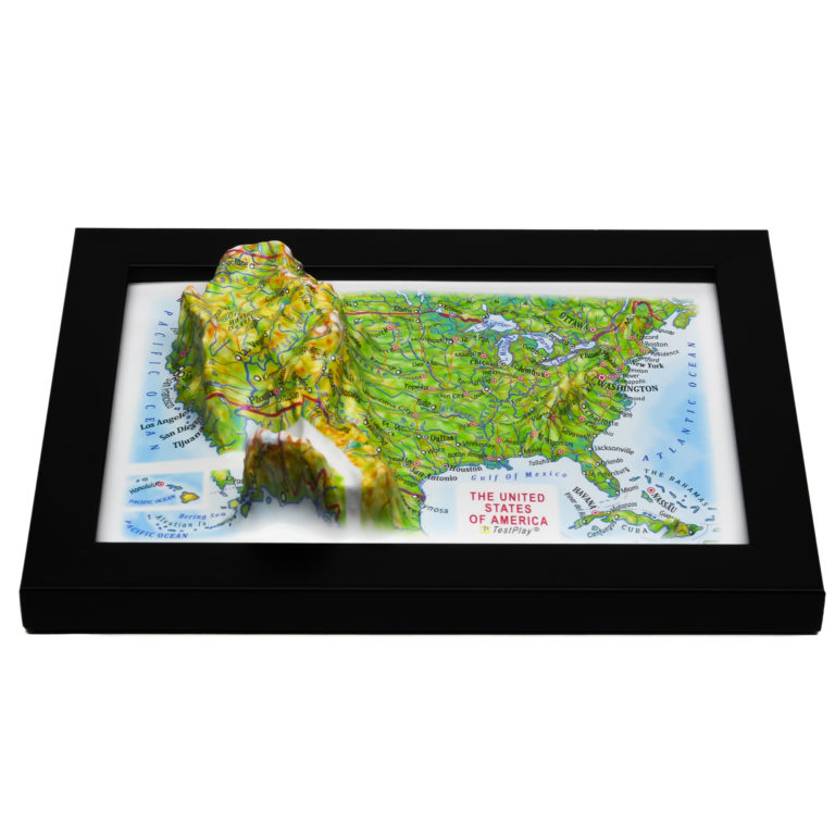
United States 3D Map
Product Specifications:
✅ SIZE:
4 inches x 6 inches
(100 x 150 mm)
✅ 3D RELIEF HEIGHT:
Up to 1.5 inches (40 mm)
✅ MAP SCALE:
1 inch = 607 Miles
(1:38,500,000)
List of Countries 3D Maps
About Countries 3D Maps
Raised relief technology adds tangible depth to each country’s terrain, allowing mountain ranges, valleys, plateaus, and coastlines to be clearly felt and visually understood. The panoramic bird’s-eye view presents elevation layers and landforms with clean spatial clarity.
Beyond exploration, Countries 3D Maps with Raised Relief serve as premium travel souvenirs and refined decor pieces. Designed for wall or desk display, they bring geography, travel memories, and elegant craftsmanship into modern interiors.
Contents of Available Now 3D Maps
List of National Parks 3D Maps
- Acadia National Park 3D Map
- Arches National Park 3D Map
- Cuyahoga Valley National Park 3D Map
- Glacier National Park 3D Map
- Grand Canyon National Park 3D Map
- Grand Teton National Park 3D Map
- Great Smoky Mountains National Park 3D Map
- Mount Rainier National Park 3D Map
- Olympic National Park 3D Map
- Rocky Mountain National Park 3D Map
- Shenandoah National Park 3D Map
- Yellowstone National Park 3D Map
- Yosemite National Park 3D Map
- Zion National Park 3D Map
List of Countries 3D Maps
List of States & Islands 3D Maps
List of Cities 3D Maps
List of Cities Mecca & Medina 3D Maps
List of 3D Ski Maps
- Alpine Meadows 3D Ski Map
- Alta 3D Ski Map
- Aspen Highlands 3D Ski Map
- Aspen Mountain 3D Ski Map
- Beaver Creek 3D Ski Map
- Big Sky 3D Ski Map
- Breckenridge 3D Ski Map
- Buttermilk 3D Ski Map
- Copper Mountain 3D Ski Map
- Deer Valley 3D Ski Map
- Heavenly 3D Ski Map
- Jackson Hole 3D Ski Map
- Keystone 3D Ski Map
- Killington 3D Ski Map
- Mammoth Mountain 3D Ski Map
- Northstar 3D Ski Map
- Okemo Mountain 3D Ski Map
- Palisades Tahoe 3D Ski Map
- Park City 3D Ski Map
- Powder Mountain 3D Ski Map
- Snowbird 3D Ski Map
- Snowmass 3D Ski Map
- Steamboat Springs 3D Ski Map
- Taos Ski Valley 3D Ski Map
- Telluride 3D Ski Map
- Vail 3D Ski Map
- Winter Park 3D Ski Map
Contents of Portfolio 3D Maps
List of Mini Format 3D Maps
- Austria 3D Map Mini
- China 3D Map Mini
- France 3D Map Mini
- Germany 3D Map Mini
- Greece 3D Map Mini
- Italy 3D Map Mini
- Kazakhstan 3D Map Mini
- Russia 3D Map Mini
- Scotland 3D Map Mini
- Switzerland 3D Map Mini
- United Kingdom 3D Map Mini
- Crete 3D Map Mini
- Le Grand Paris 3D Map Mini
- Moscow Oblast 3D Map Mini
- Colorado 3D Map Mini
- New York State 3D Map Mini
- Texas 3D Map Mini
- Washington 3D Map Mini
- London 3D Map Mini
- Los Angeles 3D Map Mini
- New York City 3D Map Mini
- San Francisco 3D Map Mini
- Sochi 3D Map Mini