
Santa Catalina Island 3D Map | Raised Relief Map by TestPlay
🔖 TestPlay’s 3D maps with a panoramic effect are masterpieces of miniature realism. This Santa Catalina Island 3D map region by TestPlay is a true masterpiece, bringing the breathtaking landscapes of this Pacific island to life in refined detail. It’s more than just a map; it’s a tangible piece of this iconic coastal retreat brought into your hands
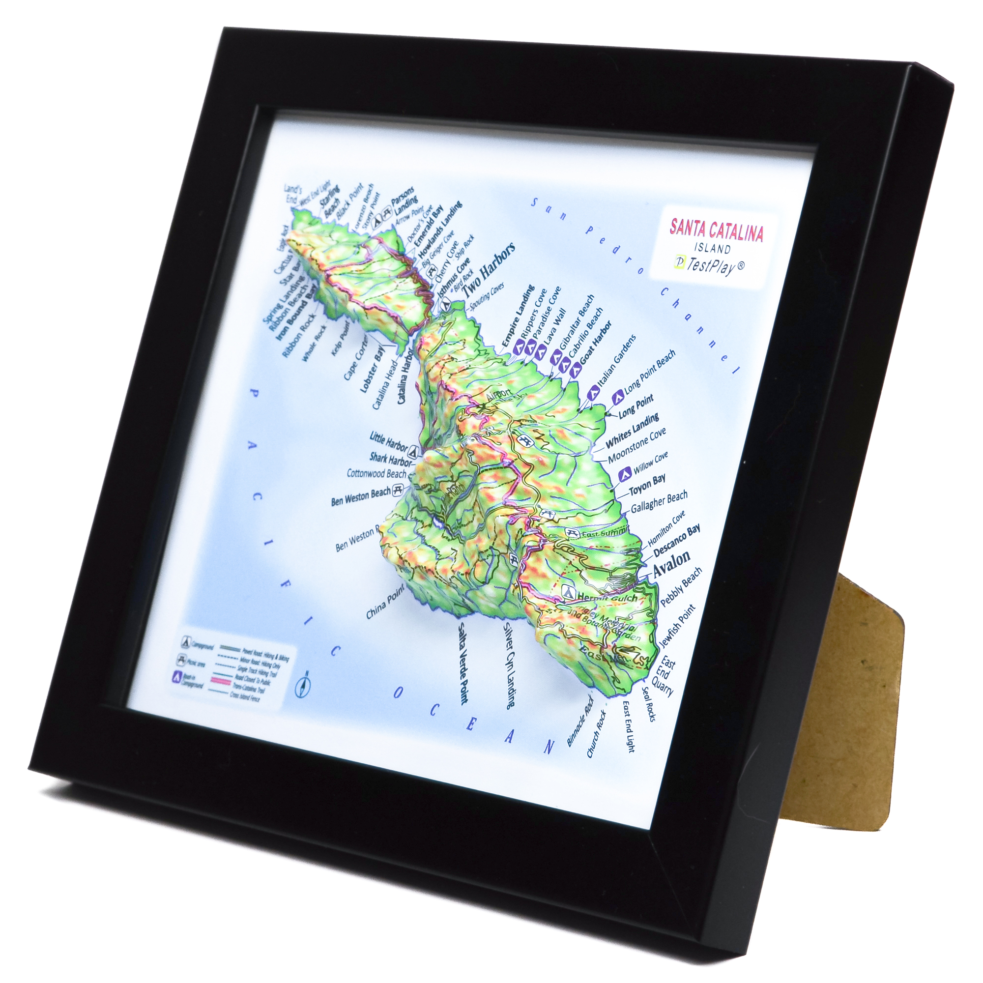
Product Specifications
This meticulously crafted Santa Catalina Island 3D Map brings the region to life with precise detail:
- Length: 4.5 inches (116 mm)
- Width: 5.25 inches (132 mm)
- 3D Relief Height: Up to 1.1 inches (28 mm)
- Map Scale: 1 inch = 4.4 Miles (1:280,000)
Price: $39.00
Interested in carrying TestPlay maps in your store?
We are open to wholesale partnerships worldwide. For cooperation inquiries, please contact us →


Experience the Sunshine State in 3D
Santa Catalina Island rises dramatically from the Pacific Ocean just off the coast of Los Angeles, revealing a rugged spine of mountains, winding canyons, and secluded coastal coves. Catalina is defined by its pronounced central ridge. Steep slopes descend toward the sea on both sides, creating a striking sculpted landscape.
The island stretches approximately 22 miles (35 kilometers) in length and is crowned by Mount Orizaba, which reaches 2,096 feet (639 meters) above sea level. Scenic routes and trails traverse the terrain, connecting hidden harbors, quiet bays, and the island’s two main settlements — Avalon and Two Harbors — each nestled within natural coastal formations.
On this 3D map, intricate elevation changes, ridgelines, and shoreline contours are rendered with refined clarity, revealing how the island’s geography shapes its character. Soft natural tones transition from sunlit slopes to sheltered valleys and rocky shores, enhancing the panoramic effect and transforming Santa Catalina Island into a distinctive keepsake for travelers, sailors, and nature lovers.
Why Choose TestPlay’s 3D Region Maps?
TestPlay’s 3D region maps present distinctive landscapes from a clear bird’s-eye perspective. Each raised relief map accurately visualizes mountains, valleys, rivers, coastlines, and elevation changes, revealing the natural character of a region at a glance.
These 3D topographic maps highlight how terrain shapes local environments and cultural areas. They make it easy to understand geographic features, scale, and the unique identity of each region.
Designed for travelers, geography enthusiasts, and explorers, TestPlay’s 3D region maps are perfect for trip planning, remembering meaningful places, or discovering new destinations. They transform regional landscapes into clear, tactile forms.
The realistic relief and refined surface details make every region instantly recognizable.
Each 3D region map becomes a conversation piece for sharing travel stories and exploring the character of different landscapes.
With an elegant Art Deco–inspired design and a compact format, TestPlay’s 3D relief maps of regions fit naturally into any interior. They complement homes, offices, studios, schools, and hospitality spaces.
A thoughtful gift for travelers, map lovers, and those connected to a particular place.
A Timeless Regional Keepsake
Each TestPlay 3D region map is a lasting tribute to the character of a landscape.
It reflects a personal connection to a place and the memories tied to it.
It is decor and a timeless regional keepsake.
Contents of Available Now 3D Maps
List of National Parks 3D Maps
- Acadia National Park 3D Map
- Arches National Park 3D Map
- Cuyahoga Valley National Park 3D Map
- Glacier National Park 3D Map
- Grand Canyon National Park 3D Map
- Grand Teton National Park 3D Map
- Great Smoky Mountains National Park 3D Map
- Mount Rainier National Park 3D Map
- Olympic National Park 3D Map
- Rocky Mountain National Park 3D Map
- Shenandoah National Park 3D Map
- Yellowstone National Park 3D Map
- Yosemite National Park 3D Map
- Zion National Park 3D Map
List of Countries 3D Maps
List of States & Islands 3D Maps
List of Cities 3D Maps
List of Cities Mecca & Medina 3D Maps
List of 3D Ski Maps
- Alpine Meadows 3D Ski Map
- Alta 3D Ski Map
- Aspen Highlands 3D Ski Map
- Aspen Mountain 3D Ski Map
- Beaver Creek 3D Ski Map
- Big Sky 3D Ski Map
- Breckenridge 3D Ski Map
- Buttermilk 3D Ski Map
- Copper Mountain 3D Ski Map
- Deer Valley 3D Ski Map
- Heavenly 3D Ski Map
- Jackson Hole 3D Ski Map
- Keystone 3D Ski Map
- Killington 3D Ski Map
- Mammoth Mountain 3D Ski Map
- Northstar 3D Ski Map
- Okemo Mountain 3D Ski Map
- Palisades Tahoe 3D Ski Map
- Park City 3D Ski Map
- Powder Mountain 3D Ski Map
- Snowbird 3D Ski Map
- Snowmass 3D Ski Map
- Steamboat Springs 3D Ski Map
- Taos Ski Valley 3D Ski Map
- Telluride 3D Ski Map
- Vail 3D Ski Map
- Winter Park 3D Ski Map
Contents of Portfolio 3D Maps
List of Mini Format 3D Maps
- Austria 3D Map Mini
- China 3D Map Mini
- France 3D Map Mini
- Germany 3D Map Mini
- Greece 3D Map Mini
- Italy 3D Map Mini
- Kazakhstan 3D Map Mini
- Russia 3D Map Mini
- Scotland 3D Map Mini
- Switzerland 3D Map Mini
- United Kingdom 3D Map Mini
- Crete 3D Map Mini
- Le Grand Paris 3D Map Mini
- Moscow Oblast 3D Map Mini
- Colorado 3D Map Mini
- New York State 3D Map Mini
- Texas 3D Map Mini
- Washington 3D Map Mini
- London 3D Map Mini
- Los Angeles 3D Map Mini
- New York City 3D Map Mini
- San Francisco 3D Map Mini
- Sochi 3D Map Mini